This website uses cookies
This website uses cookies to enable it to function properly and to analyse how the website is used. Please click 'Close' to accept and continue using the website.
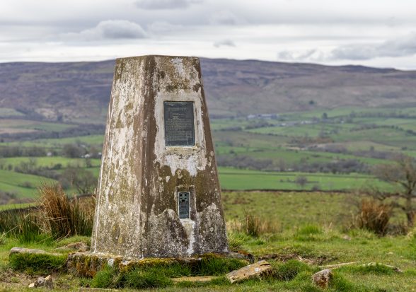
Image credit: C20 Society
Britain’s mountain summits, upland fells, moorlands, crags, downs and beacons are dotted with around 6,500 Trig Pillars: shorthand for Trigonometrical Stations and more commonly known as Trig Points. These modest obelisks of modernity in the countryside are remnants from a nationwide surveying project of unprecedented scale that is this week celebrating its 90th anniversary. Today they’re a target for recreational ‘trig-baggers’ and a reassuring beacon for outdoor lovers, offering commanding 360° viewpoints and a satisfying photo opportunity at the end of a strenuous climb. Yet remarkably, not one of these features on any national heritage list
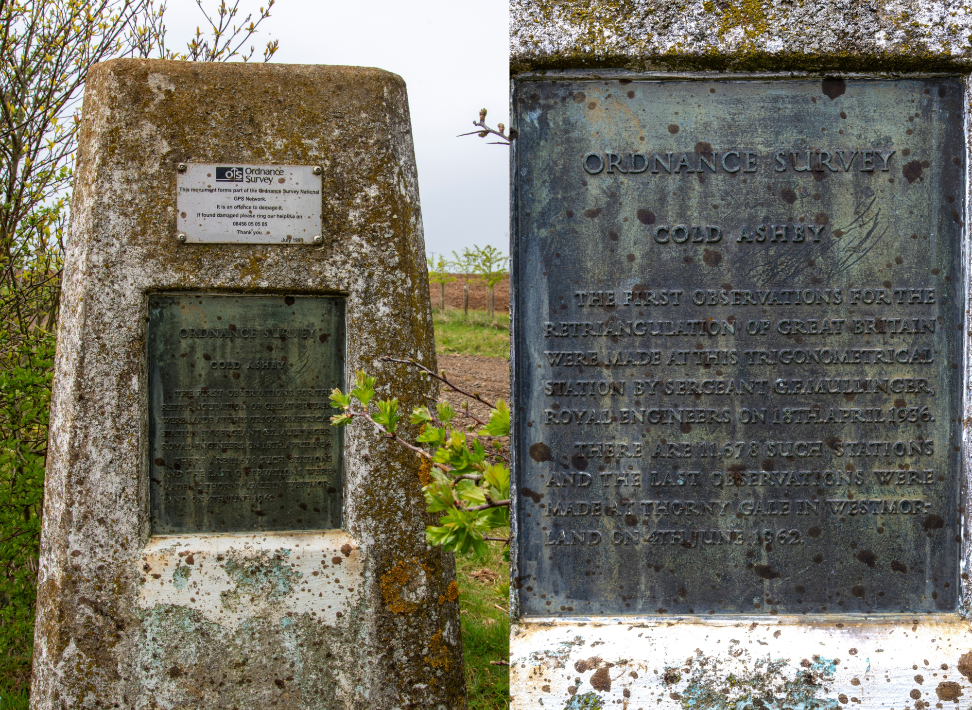
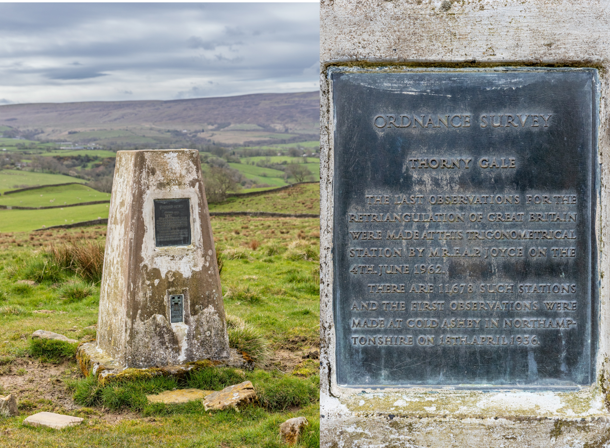
Twentieth Century Society has submitted listing applications to Historic England for the two most historically significant examples: the pillar at Cold Ashby in Northamptonshire, site of the very first observations on 18 April 1936 (Grid Ref: SP 64422 76588), and the pillar at Thorny Gale, near Appleby-in-Westmoreland in Cumbria (Grid Ref: NY 82516 13912), site of the final observations, taken on 4 June 1962. Both survive in excellent condition and have large bronze plaques set into their flanks, memorialising their bookending role in mapping the British landscape.
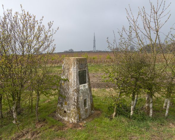
Image credit: McCoy Wynne Photography (from the Triangulation project)
Retriangulation of Great Britain
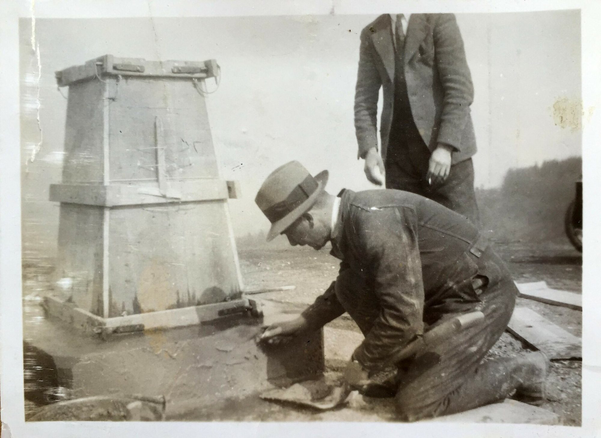
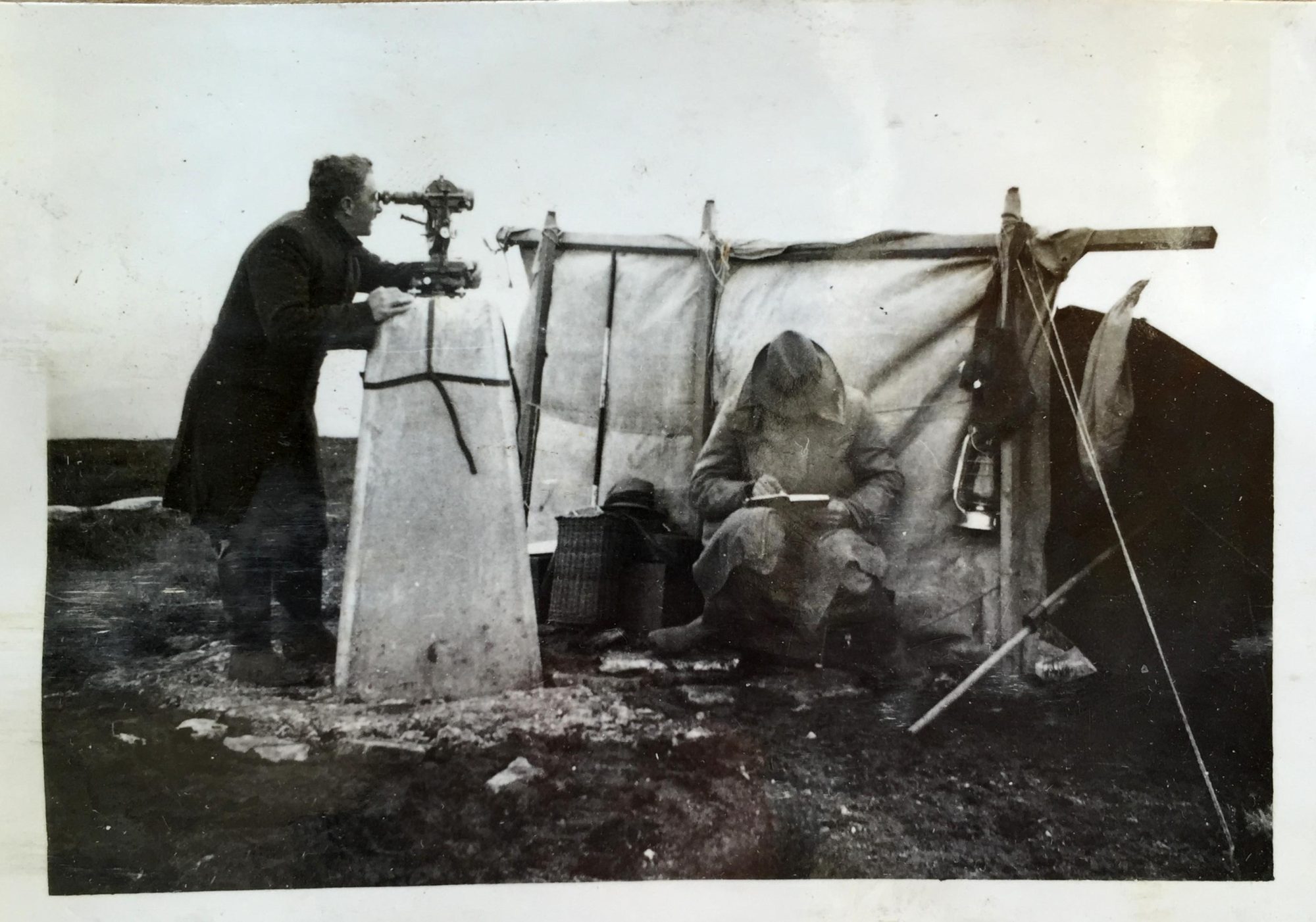
After the First World War, mapmaking in Britain was still reliant on the Principal Triangulation, a haphazard and piecemeal collection of measurements taken between 1783 and 1853. As the country developed rapidly in the Interwar years, more detailed maps were needed and the old data was no longer sufficient. This led to the Retriangulation of Great Britain project, spanning 1936 to 1962; the basis of our modern mapping systems, the foundation of the Ordnance Survey National Grid, and birth of the Trig Pillar.
Designed in 1935 by Brigadier Martin Hotine (1898-1968), the now familiar Trig Pillar is a truncated square-based pyramid that tapers towards the top, generally 4ft high and constructed of concrete or locally hewn stone. The flat top surface provided a solid base for theodolites to be positioned on a three-grooved brass plate called a ‘spider’. These were the precision instruments used by survey teams to improve the accuracy of the readings they obtained. With these readings they triangulated (or separated) the whole of the country into a network of triangles, calculating the angles of landmarks and features from either side of a defined baseline, and accurately mapping the land with in-excess of 30,000 coordinated points.
Time and technologies move on, and in the 21st century Trig Pillars are now more or less obsolete, their original purpose long since surpassed by the use of GPS satellites, aerial images and drones, that have mapped the country down to millimetre accuracy. In the early 1990s the Ordnance Survey decided that they no longer needed the majority of Trig Pillars and did not want to incur the ongoing maintenance costs, so proposed removing unwanted pillars or leaving them to deteriorate gradually.
After a backlash from the Ramblers Association and other groups, the OS relented and an adoption scheme was launched in 1992, whereby individuals and local community groups could take over the basic maintenance tasks of pillar and call them their own – much like that other 20th century favourite, telephone boxes. Despite initial enthusiasm for adoptions, there were unresolved issues around right of access, continuity of support and high administrative costs. The scheme was ultimately abandoned, though unofficial adoption and volunteer maintenance continues at some sites.
Catherine Croft, Director – C20 Society
“Long before GPS, satellite technology, and navigational apps on our mobile phones, Trig Points were the humble concrete pillars that mapped a nation – more than 6,500 of them in total. As the landmark ‘Retriangulation of Great Britain’ celebrates its 90th anniversary, we spied an opportunity to put a figurative pin-in-the-map and have submitted the two most historically important Trig Points – the first and last examples – to be nationally listed. Nothing beats the modest triumph of standing on top of a Trig Point in a brisk wind and we hope these two modern obelisks of concrete in the countryside will soon be recognised by DCMS (The Department for Culture Media and Sport).”
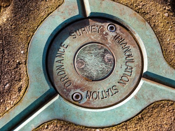
Image credit: Paul Biggins
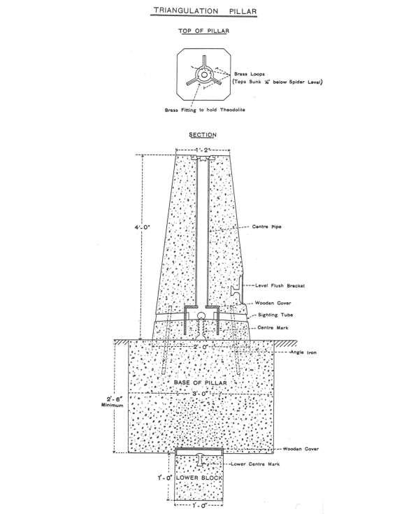
Image credit: Ordnance Survey, Creative Commons
Become a C20 member today and help save our modern design heritage.